 |
|
Introduction
The central part of Japan's main island, Honshu, which consists of eight ken (prefectures) , is known as the Chubu District. The country's highest mountains are located in this area. For a rough overview check out this map.
Even though Japan has increasingly gained economical importance in recent years, most people in the west know very little about this country. There are several reasons for this: Japan remains a rather expensive travel destination, the language barrier makes individual touring rather difficult, etc. Most of the English travel literature basically covers the top sightseeing spots such as Kyoto and Nara.
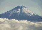
Everybody knows the distinctive cone Fuji-san, of course, thanks to its elevation of 3776 m by far the highest mountain and symbol of the country. But the fact that the Japanese archipelago is mostly mountainous is little known. Here a few figures:
| Total Land Area | Mountains and Forests | Industry and Agriculture | Inhabitated Area | Population |
|---|---|---|---|---|
| 378.000 km² | appr. 65% | appr. 20% | appr. 15% | appr. 125 Mio. |
These data give an idea of the densely populated living conditions in the cities, on the other hand there remains a large, comparatively unspoiled area of mountainous terrain. Except in the summer months July and August very few people venture in these mountains, and it is possible to go trekking here for several days without meeting anyone.
Setup of these Pages
The main section of this web site is still my Photo Gallery. I am also working on a description of individual hikes, and for those of you who are interested in statistics there is a list of the highest peaks in Japan.
If you have any comments or questions, you are welcome to send me a message at mail@japantrek.de - I am (almost) always glad when I receive some e-mail.
|
|
|
|
|
|